Neighborhood Considerations
Potential effects on surrounding neighborhoods, based on the scope described in the applicant's own filing.
The Site: Current vs. Proposed
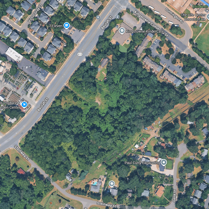
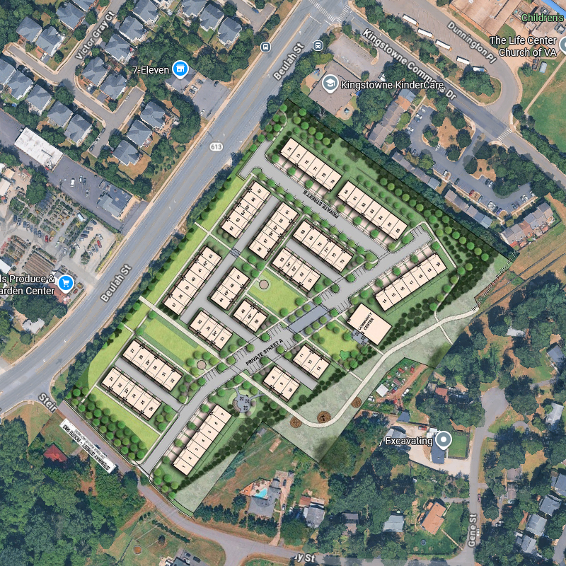
Satellite imagery via Google Maps. Proposed overlay from applicant site plan rendering.
Construction
The proposed scope — 86 units, private streets, underground stormwater facilities, structured utilities, multi-story construction — would reasonably require construction activity over multiple years.
Residents on Steinway Street and in Queens Court would be most directly affected. The single proposed access point on Steinway means construction traffic (material deliveries, concrete trucks, heavy equipment) would be concentrated on a residential street.
Traffic and Access
All vehicle access to the 86-unit community would be via a single driveway on Steinway Street, despite the property's Beulah Street frontage. All resident, visitor, service, delivery, medical transport, and rideshare traffic would flow through Steinway.
A Traffic Impact Analysis (TIA) has been required by the county. Even age-restricted communities generate traffic beyond typical commute patterns — shift changes, medical appointments, deliveries, and visitor peaks throughout the day. The proposed 24/7 operation means activity is not limited to business hours.
Privacy and Scale
Four-story buildings at approximately 50 feet would represent a significant change in visual character. Existing homes on Steinway are single-family residences on half-acre lots. Queens Court consists of two- to three-story townhomes.
The applicant has requested reduced transitional screening and elimination of the required barrier along the southern property line. If approved, this would reduce the buffer between existing homes and the new development.
Tree Canopy and Wildlife
The site is approximately 90% forested. This mature canopy provides privacy screening, wildlife habitat (deer, fox, rabbits, and various bird species are commonly observed), natural stormwater absorption, and the wooded character that drew many residents to this area.
The applicant has requested a waiver from standard tree preservation requirements. While the application references open space, the waiver indicates that a significant portion of existing mature trees may not be retained.
Neighbors are encouraged to document local wildlife sightings to help establish what currently lives in and around this habitat.
Source: Statement of Justification, p. 5.
Stormwater
Converting 10.9 acres from forested land to buildings, private streets, and paved surfaces fundamentally changes how stormwater moves through the area. Forested soil absorbs rainfall naturally; impervious surfaces redirect it as runoff.
The application references underground stormwater facilities. Their adequacy and effect on neighboring properties will be evaluated during the county review. Neighbors downstream of the site should monitor this closely.
Utilities and Infrastructure
A county notice dated February 9, 2026 indicates that the property currently relies on a well and/or septic system. Transitioning to public water and sewer to support 86 units would require utility extension, associated construction, and coordination with Fairfax Water and the Department of Public Works. This introduces additional environmental disturbance and infrastructure impacts beyond those of the buildings themselves.
The current utility situation underscores that the site is not presently configured for the intensity of development proposed.
Source: PLUS Record SE-2025-FR-00044, Condition Notice, 02/09/2026.
Density
The current plan designates this site at 1–2 dwelling units per acre. The proposal represents approximately 8 du/ac — a fourfold to eightfold increase. The county's own zoning analysis notes that removing these parcels from the existing subdivision would further aggravate nonconformity with R-1 standards.
Source: FR-031 One Pager; County Zoning Interpretation, March 2025.
Cumulative Impact
This proposal does not exist in isolation. Other pending applications, rezonings, and site plans in the surrounding area may compound effects on traffic, infrastructure, and neighborhood character. The cumulative impact is a reasonable consideration for the county's review.
Track active applications: Fairfax County PLUS
A Note on Perspective
These considerations are based on the applicant's filings and publicly available county records — factual observations, not conclusions. The county review process exists to evaluate these factors. Neighbors are encouraged to engage constructively in that process.